At Geomount Inc., we combine geospatial intelligence, environmental insight, and digital innovation to help shape resilient, efficient, and sustainable communities. From infrastructure design and mobility integration to climate risk assessment and UAV-enabled monitoring, our solutions are tailored to meet the evolving needs of municipalities, developers, and infrastructure leaders.
We understand that every project is unique. That’s why we begin by listening—working closely with you to identify the most effective, data-driven path forward. Our experienced team, supported by a multidisciplinary advisory board, blends practical engineering, advanced remote sensing, and strategic planning to deliver results that are future-ready and environmentally responsible.
Whether you’re managing water systems, assessing urban growth, or planning for long-term climate resilience, Geomount is your partner in building smarter, greener, and more adaptive solutions.
Let’s turn complex challenges into clear solutions. Connect with our team to explore how Geomount Inc. can support your next project with precision, insight, and innovation.
Schedule your consultation today—your smarter infrastructure starts here.
At Geomount Inc., we provide consulting, inspection, monitoring, and insight-driven design for resilient and sustainable infrastructure. By integrating geospatial intelligence, environmental data, and advanced analytics, we help Canadian communities plan smarter and build stronger.
Using multisensory data from UAV LiDAR, thermal imaging, GPR, and environmental sensors, we turn complex information into clear and actionable strategies for performance, compliance, and resilience.
Lighting, mobility, and efficiency optimization studies
Geospatial aI
Geomount Inc. harnesses geospatial artificial intelligence to power three cloud platforms currently in beta development. These tools apply deep learning to enable dynamic spatial insights, transforming how we monitor water bodies, assess infrastructure, and plan land use. Join us in building the next generation of spatial intelligence.
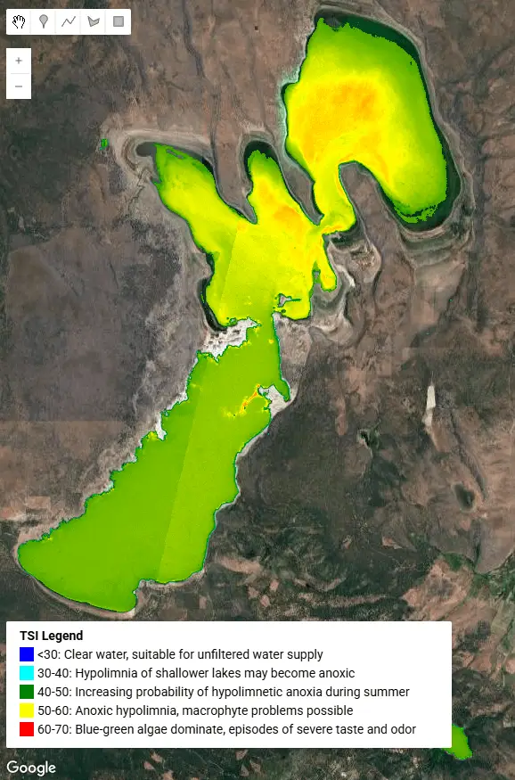
A cloud-based platform for historical and real-time assessment of water quality in lakes, ponds, and rivers using satellite imagery supporting long-term conservation and ecological planning.
Water Quality Insights
Environmental Monitoring + Climate Resilience
Our infrastructure intelligence platform provides assessments of roads, bridges, and dikes, detecting surface deterioration, drainage issues, and structural risks using geospatial data analytics.
InfraScan
Sustainable Infrastructure + Geospatial Solutions
A property risk assessment platform combining floodplain, seismic, and wildfire data with elevation modeling and zoning layers. Ideal for municipalities and planners evaluating safe and strategic land use decisions.
ClimateGuard
Climate Resilience + Urban Design + Energy Strategy
RECENT PRoJECTS
Geomount Inc. uses advanced multisensory technologies within its precision workflows to support infrastructure planning, environmental monitoring, and urban development with accuracy and efficienc